Minister of Rural Development and Panchayati Raj to launch Rural Connectivity GIS Data in Public Domain tomorrow
PIB News with News Investigation

GIS Data for 800,000+ rural facilities, 1 Million+ habitations and 25,00,000 km+ of rural roads collected and digitised using GIS platform will be made available to the public
National Rural Infrastructure Development Agency (NRIDA) will be signing MoU with 3 renowned GIS Firms & collaborating with Gati Shakti for releasing the Rural Connectivity GIS Data in Public Domain
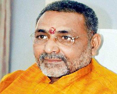
Union Minister for Rural Development and Panchayati Raj Shri Giriraj Singh will launch Rural Connectivity GIS Data in Public Domain at 12 PM on 22nd February, 2022 in India Habitat Centre, New Delhi.
Pradhan Mantri Gram Sadak Yojana (PMGSY) was launched in the year 2000, with an objective to provide all-weather road connectivity to eligible unconnected habitations throughout the nation. Later on upgradation and consolidation of through routes and major rural links was also included as its objective to give fillip to the rural economy. Since inception, 7.83 lakh Km roads have been sanctioned and 6.90 lakh Km have been constructed with an expenditure of Rs. 2.69 lakh crores.
As part of the implementation of PMGSY, GIS data for 800,000+ rural facilities as points, 1 Million + habitations and 25,00,000+ km of rural roads have been collected and digitised using GIS platform developed for the scheme. The collected rural connectivity GIS data will be available to the public.
NRIDA, the nodal implementation agency of PMGSY scheme will be signing MoU with 3 renowned GIS Firms & collaborating with Gati Shakti for releasing the Rural Connectivity GIS Data in Public Domain. Gati Shakti is a national master plan and digital platform to plan and execute infrastructure projects in India to reduce logistics costs and enhance infrastructure. NRIDA is collaborating with Gati Shakti with an objective to exchange the data for the better planning and implementation of both the schemes.
The launch of GIS data will be followed by technical session where presentation by ESRI India, MapmyIndia, DataMeet, Gati Shakti and CDAC Pune will be made.


